
Take a look at this photo:

Do you see anything sad here? Take a closer look…

Yes, my India visa has expired. I’m sad, I loved visiting that place. Only made it there three times. I definitely want to return.
Take a look at this photo:
Do you see anything sad here? Take a closer look…
Yes, my India visa has expired. I’m sad, I loved visiting that place. Only made it there three times. I definitely want to return.
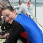
On Monday the 12th, I took Claire scuba diving. She thought the dive was awesome. Definitely one of the highlights of our vacation.


We arrived at the shop around 10:40, Manta Divers. We paid our 2000 pesos ($142) and they fixed my mask. We started with a discussion pool-side where Marin (pronounced ‘Marine’) gave Claire some Scuba theory. Properties of air, going over the equipment, etc.
Next we moved to the pool where Claire had to master a half-dozen skills, which she picked up quickly. Marin asked if our masks had been treated with anti-fog treatment or toothpaste (which does the same thing.) I had forgotten, so he showed us a clever trick. He pulled out a lighter and used the flame to burn off residue on the inside of each goggle’s tempered glass lens. We wiped the smoke smudging off, and did it again. What a cool trick, it worked perfectly!
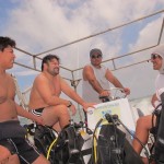
When the rest of the group arrived for the dive, we climbed aboard our boat, which was named ‘Nemo’. It was a dumpy-looking, low-slung boat, complete with copyright-infringing “Finding Nemo” logo on the side.) It used to have an awning, but the crew said it had torn off on a dive trip some time ago, leaving just the steel frame. The other three divers were allegedly Mexicans, but they only spoke English. They looked and sounded Russian. There was a big bald one, and two smaller guys with dark hair, one with a crew cut. They looked sort of like a trio of Russian Mob strongmen on their day off. Marin was our dive master so he came along as well, along with the boat pilot and another guy who helped everyone put on their gear. We also were joined by “Alex”, a photographer who came along to document our trip with photos and video.

Claire was the only beginner, which was really nice. Marin could give her 90% of his attention.
 We went across the lagoon, through a channel next to the Pirate ships and over to Machiones reef, which is just off the south end of Isla Mujeres. When we got there the dive master jumped in first, then had Claire flip sit on the side of the boat and flip in backwards. There was a big ball buoy attached to a rope, they used it to descend. It took Claire awhile to master equalizing her ears, so I sat at the bottom and waited until she made it down there. Marin was quite patient with her.

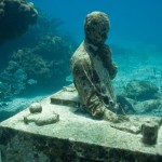
 Once she got down there, off we went. We were at the underwater sculpture museum so we swam over to see a number of statues. On the way the dive master flipped over a rock and showed us some sea spiders (that’s what they looked like) and some sea stars, an unusual half-eel, half-fish, and fire coral.
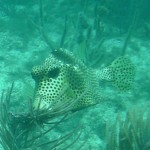
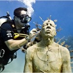
 He also caught a trunkfish and passed to Claire, she had it caged within her fingers for a moment, then released it. Pure joy!
When our air ran low we surfaced and moved to another spot. On the way they spotted a fish floating on the surface. Evidently it was caught and lost by a fisherman so they slowed down and grabbed it. Dinner perhaps? When we reached our second location they put another tank on our equipment and we jumped in again.
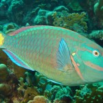
This location had more reef and Claire came down much quicker. We swam around all around the reef, looking at the coral and the amazing fish. Like the first location there were huge schools of yellow fish organized in evenly-spaced groups. Claire enjoyed making quick movements at them to see them all bolt in unison. We picked up an empty sea urchin shell on the bottom, but it broke a few minutes later so we abandoned it. There were lots of rainbow-colored parrotfish, big black angelfish, and other angels that were neon blue and yellow.
 All too soon, the dive master gave the “all up” signal. We slowly ascended back to the surface. On the way up he entertained us by blowing ring-shaped bubbles. We were a little ways from the boat so we kicked over to it, grabbing a rope on the side before removing our fins and tanks.
On the way back to the Hotel Zone we passed a couple of sea turtles swimming on the surface. We passed the pirate ships then went through a channel in the Mangroves alongside the highway. There was a quiet area along the bank of the lagoon where Mexican families were playing in the water.
When the boat reached the dock, the crew set out a large conch shell for tips. I was the only one who tipped the crew, which I thought was odd. I guess Russians don’t tip.
We showered to wash off the salt water, and washed off our gear. We then returned it to the shop. In the front of the shop the photographer had set up his camera to review the photos and video. It was fun to see the pictures of Claire by the underwater statues, and the video of her with the trunkfish, but it was $60 for the set (video and photos) and Claire didn’t seem particularly interested, so we passed on his offer. I do wish we had a copy of just a couple of the photos, but oh well.
We got back to our room around 6. The day went so fast!
Back at the room, Jenny was in bed with a bad Migraine. I ran across the street to a Farmacie and bought some generic imitrex (no prescription needed in Mexico!) She didn’t feel well enough to go out so the rest of us went on a drive for food. We stopped at the Mexican Souvenir Outlet we had passed so many times. It was a giant, American-style gift shop. They had a huge selection of souvenirs, all priced in US dollars. Everything was priced much higher than we were used to seeing everywhere else. We saw the exact same T-shirts we bought at Wal Mart (Sophie and I were wearing ours) at double the price.
We ended up at El Fish Fritangas, the restaurant underneath the taco shop with the same name that we ate at so many times. Our table was on the sand, next to the shore of the lagoon. We watched the sun set, and the girls all said how they wished mom were there to see how pretty it was. We ordered more food than we could eat.
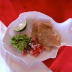
 The kids thought the meal was great. Most had fish, Sophie had guacamole, then went upstairs to the taco shop and got some tacos instead. I had some sort of thing that was a stack of small corn tortillas with beans in between, smothered with some kind of enchilada sauce. It was supposed to have some nurse shark meat too, but I couldn’t find it. It wasn’t very good, so I helped Isabelle finish off her breaded fish filet, which was great.
 After we ate, a magician appeared for a show. For his final trick he asked for a “paper bill”. I pulled out the smallest bill I had, since I figured I wasn’t going to see it again, and I hadn’t seen our bill yet so I needed to conserve cash. He pointed out that that bill is plastic. (the smallest paper bill is a 100peso, $7). So I pulled out a paper receipt and told him that’s all the paper I had. He wasn’t too thrilled but he finished his trick and then left.
 The whole bill thing was a little odd. They brought the bill, and I put the exact amount with the bill, then started to figure out the tip. The Manager appeared by my side, counted the cash, and reminded me that the total did not include a tip. I told him I was figuring it out and he stood next to me as I did the math. I gave him a 200 peso bill, and asked him I’d he could make change. He counted the money again, and started to walk off. I told him “just a minute, let me figure out the total.” He was in a hurry. I figured out the tip, added it to the check as he waited for me. He seemed really anxious to get us wrapped up and out of there. I commented about it, he said they were really busy. I looked around at the half-filled restaurant and shrugged. He added, “but the entertainment is free!” nodding at the Mayan dance show going on next door. We finished and left.